Tuesday, August 13, 2013

Letter from Manzoor Hussain - President of Alpine Club of Pakistan


Dear Steve,

I thank the American climbing community and yourself for the thoughts and condolences in this hour of our shock and grief which we suffered due to the traumatic and brutal massacre of 10 innocent guest mountaineers and one local staff on the night of 22nd June 2013 at the Diamer Base Camp of Nanga Parbat, in Gilgit –Baltistan. It was painful for us to receive the bodies and then listen to the survivors and those climbers who were on the higher camps during that night. I personally apologised to the concerned federations, to the 43 mountaineers who were brought back to Islamabad on 24th June and the bereaved families, some of whom were in Islamabad to receive bodies of their kith and kin. ACP also held a Condolence Reference for the killed mountaineers on 25th June which was attended by all the Nanga Parbat mountaineers, government officials, ACP members and others. Nazir and I worked closely since he received the information early morning on 23nd June.     

We coordinated shifting of all NP mountaineers from Diamer Base Camp to Chilas by the Army helicopter sorties and its land transportation to Islamabad and handing over the stuff to all the mountaineers, including the deceased ones to expedition leaders on 29th June. I may mention that bodies of the killed mountaineers were despatched to their respective countries by Air force planes by the Government of Pakistan on 27th June.  Later baggage of the killed Ukrainian and Slovakian mountaineers was also despatched by special Air force plane on 30th June.

The masses and the Government of Pakistan have been shocked and jolted by this unfortunate tragedy and we are already working to revise our procedures and security system in the mountain areas to make the area secure for all the visitors to the areas.

Regards

Manzoor Hussain
President
Alpine Club of Pakistan

Thursday, June 27, 2013

Attack on Climbers in Pakistan

I've been on eleven climbing expeditions to Pakistan.  Although the Country has been destabilized by the war in neighboring Afghanistan, sectarian violence, and a growing insurgency, I have always told my family and friends that the areas where we go climbing are safe.  The Karakoram and Himalayan mountains in northeastern Pakistan are stunningly beautiful, and contain a significant number of the world's greatest mountains including K2, the world's second highest.  They attract mountaineers and trekkers from all over the world, and.were a safe haven from the terrorist violence that has afflicted other parts of Pakistan.  All that changed on June 22nd, when Pakistani militants killed ten mountain climbers at the Nanga Parbat base camp.  I will try to summarize the events that led to these killings and how this might affect mountaineering and trekking groups in the future. 

The victims of this attack were climbing Nanga Parbat, the ninth highest mountain in the world which is located in the Province of Gilgit Baltistan in northeast Pakistan.  Gilgit Baltistan is well to the north and east of the Afghan border areas in Balochistan, the Federally Administered Tribal Areas (FATA), or Kyber Pakhtunkwa (KPK) where most of the militant violence has occurred.  Much of this violence is associated with the war in Afghanistan and a very porous border between the two countries. 

Pakistan and Kashmir

Gilgit Baltistan is part of a larger historical region called Kashmir that is currently divided between the nations of China, India, and Pakistan.  Kashmir is comprised of the brown shaded areas in the above map.  The light brown areas, including Gilgit Baltistan, are the areas of Kashmir controlled by Pakistan.  Several wars have been fought between India and Pakistan, and one between India and China over ownership of Kashmir.  This 66 year old dispute is one of the leading causes of political instability in South Asia.

Besides Kashmir, the other more familiar and major source of political instability is the conflict over control of Afghanistan after the Soviets were expelled in 1989.  The Afghan Taliban (Pashtun Sunni Muslims from the south) took control of most of the country in 1996 from warlords who had been fighting each other since the Soviets had left.  The Taliban implemented a very strict form of Sharia Law and also harbored jihadist groups like Al Qaeda (Sunni Arabs) run by Osama bin Laden who planned the 9/11 attack on the US.  After 9/11, the Afghan Taliban would not eliminate this safe haven for Al Qaeda so the US allied itself with several northern tribes that had not been conquered.  This Northern Alliance, with support from the US, defeated the Taliban, forcing them to flee Afghanistan.  Pakistan had been an early supporter of the Afghan Taliban as a way to gain influence and power in Afghanistan so they allowed them to escape across their border into FATA and KPK.  The Afghan Taliban were heavily armed and experienced fighters and created their own semi-autonomous areas within FATA and KPK by eliminating the traditional Pakistan Government run tribal rule and replacing it with Sharia Law similar to how they governed Afghanistan in 1996-2001.  With most of these areas no longer under government control, disaffected fundamentalist Pakistanis allied themselves with the Afghan Taliban and formed their own extremist groups known as the Pakistan Taliban.

The Afghan and Pakistan Taliban groups were influenced by the Arab Al Qaeda members who were also pushed into Pakistan after 9/11.  The Al Qaeda influence caused the Taliban to became more interested in the Global Islamic Jihad, and their goals began to diverge from those of their Pakistani benefactors who had been using them as proxies in Afghanistan and Kashmir. The Taliban killed tribal leaders and government agents when they took control and radicalized these areas within FATA and PKP.  These groups had now became a threat and the Pakistan Government engaged in several military campaigns to regain control of areas within FATA and PKP.  This resulted in thousands of civilian, militant, and security personnel deaths. 
Kyber Pakhtunkwa and FATA
The Army invaded the Swat District in KPK twice in 2009 to regain control.  In what has been called the First and Second Battles of Swat, the Pakistan Army defeated the Taliban, but the fighting caused over 2.2 million refugees to flee the District.  Many Taliban fighters escaped from the Army disguised as refugees.

A number of Taliban that fled the Swat Valley went to the Diamir district in Gilgit Baltistan close to Nanga Parbat.  The Capital of this district in GB is Chilas which sits on the Karakoram Highway (KKH) connecting Pakistan to China.  Trekkers and climbers regularly travel the KKH to get to the towns of Gilgit and Skardu.  These towns are the jumping off point for expeditions into the heart of the Karakoram Mountains further to the north and east. 

Districts in Gilgit Baltistan - The Diamir District is the peach colored area on the bottom

After the Taliban had infiltrated the Diamir District, the KKH became more dangerous so climbers and trekkers opted to fly from Islamabad to Gilgit and Skardu which were still relatively safe towns for foreigners.  The destination for these trekkers and climbers was the Karakoram Mountains which are located north and east of Gilgit and Skardu along the boundary with China.  These mountains are far away from any militant activity and adventure travelers who went there felt completely safe.

K2 from high on Broad Peak in 1987

But Nanga Parbat is dirrerent.  It is not technically part of the Karakoram Mountains since it is located to the south on the other side of the Indus River in the Astore District immediately east of Chilas.  The normal route on Nanga Parbat is up the Diamir Valley which, as I have mentioned, has been subject to Taliban infiltration since the 2001 American invasion in Afghanistan and the 2009 battles in Swat. 

Before the recent attacks, the Taliban in the Diamir District had left the foreigners pretty much alone.  In 2004 I was on an expedition in the Karakoram near the Chinese border where I ran into some German climbers who had recently been trekking in the Diamir Valley near Nanga Parbat.  They told me a story about sitting around a campfire with some of the locals and the conversation turned to whether there were Taliban in the area.  On of the locals turned to them and said nonchalantly, "we are the Taliban".  These valleys are so steep and rugged that the situation in an adjacent valley can be completely different.  On that same trip we went to climb Nanga Parbat, but from the Rupal Valley on the opposite side of the peak.  From what we could tell, there were no Taliban there.

Rupal Face of Nanga Parbat - Doug Chabot and I did the first ascent of the long Mazeno Ridge on the left - D.Scott
Tensions in the region have been heightened recently as the US and NATO are about to pull most of their forces from Afghanistan.  This pending power vacuum incites the various militant groups to gain control of as much territory as they can, thinking it will give them an advantage in any subsequent power grab.

The conflicts in Iraq and Syria have inflamed sectarian violence between Sunni and Shia across the entire region.  The Taliban are ethnic Pashtuns who are Sunni Muslims.  Although the majority of the people in Pakistan are Sunni, the people in Gilgit Baltistan are Shia.  Some think that the Taliban group which claimed responsibility for the attack on the Nanga Parbat climbers is the same as the one responsible for murdering about 30 Shias who were pulled off a bus going over the Babusar pass to Gilgit last year.  As far as I know, no actions have been taken against this group as a result of the bus attack.  

The PML-N Party won the recent Parlimentary elections returning Nawaz Sharif to a third term as Prime Minister.  It remains to be seen if the new Sharif administration is both willing and able to depart from the policies of the past.  Any significant police or military action against the Taliban would require the cooperation and full support of the Army that continues to retain control of national security and foreign policy.  The last time Sharif' was Prime Minister in 1999, he was kicked out in an Army coup. 
  
The economic impact on Gilgit Baltistan of these attacks on the climbers will be severe.  Already extremely poor, the local people in the mountains are subsistence farmers who have come to rely on income from work as porters, cooks, and guides for their only cash.  Security concerns have already badly hurt the tourism industry and this attack will likely cause it to collapse.  This happened right after 9/11 and these people who could least afford this loss of income suffered terribly.  Unfortunately this is likely to happen again.


So what does this mean for climbers and trekkers who are interested in going to Gilgit Baltistan?  These are very personal decisions that need to balance the desire to; go to a spectacular mountain place, support our local friends there, minimize security risk, and not subject our family and friends to excessive worry.  I can provide the following information on minimizing security risk based on my experience there and information obtained from people who are there now:
  • Hire a good agent who can arrange safe places to stay and do a lot of your local shopping so you can stay in your hotel.
  • Do not travel by road from Islamabad to Gilgit or Skardu.  These flights are dependent on weather and are often cancelled.  You need to allow an extra week both coming and going to wait for a flight.
  • Keep a low profile and don't advertise that you are an American
  • Avoid any places where there are militant groups as they have now decided to attack foreigners.  This would put Nanga Parbat off limits unless the Government provides adequate security personnel to guard the valley 24/7.
  • Gilgit has seen periodic bouts of sectarian violence so extra travel precautions are warranted.  Consider staying in Karimabad instead. 
I sincerely hope that we will soon see the kind of courageous leadership in the region that is needed to break the current political deadlocks so these people can live in peace and security.  With peace and security, tourism can help drive the economic development needed to provide resources for education, health care, housing, food, infrastructure, and jobs in Gilgit Baltistan.  I am hopeful that these issues will get resolved so we can continue to visit this spectacular part of the world and support our friends who have done such a wonderful job taking care of us over the years.

Tuesday, May 14, 2013

Alpine Mentors


About a month ago in early April I volunteered for a new program organized by Steve House called Alpine Mentors.  Steve was showing up in Canmore with four participants for two weeks of ice/alpine climbing in the Canadian Rockies.  Steve had been talking about this program for a couple of years and had put a lot of work into setting it up as a non-profit and obtaining some initial sponsors.  His idea came from similar club funded programs in France, Spain, Germany, Switzerland, and Slovenia.  Steve and I had witnessed some of the culminating trips for these programs in the Karakoram in Pakistan.

Steve started Alpine Mentors to begin building a similar program in North America for aspiring young alpinists.  His initial group of four participants was small, but given limited resources it seemed like a good size to beta test how something like this could work on this side of the Atlantic.  I had never participated in anything like this before and when Steve and his group arrived I wasn't too sure what I was supposed to do.  To get a better idea of what this was about, I checked out their website and found what seemed like a mission statement :

"Alpine Mentors promotes alpinism by encouraging, coaching and climbing with technically proficient young alpinists who aspire to climb the world's greatest mountains in a lightweight, low-impact style"

As one of the mentors it seemed like my job was to go climbing with the participants and provide some coaching and encouragement.  It seemed simple, but I would discover that I had a lot to learn.

Colin Simon and Marianne van der Steen on the route Nemesis
The AM website further described the program as follows:

Alpine Mentors is designed to operate on a two-year cycle where mentors help the group organize trips that advance their climbing skills with an eye towards being able to complete technical routes in the high mountains. Along the way we help connect them with different mentors. Our goal is not to build the best alpinists, but rather to help young climbers get the most from their climbing experience. 
 
AM is organized as a non-profit group and currently the mentors and climbers fund all the program's operations from our own pockets and community donations. 


Marianne van der Steen leading the crux pitch on Nemesis

I had heard that the four participants went through a rigorous selection process, and that they had been together on a successful trip to the Black Canyon in the fall.  I read on their blog that by the end of that trip some of the teams were doing linkups of long multi-pitch rock climbs.  I wasn't sure if I was going to be able to offer much to such a strong group, and after a few days in the Canadian Rockies, I found that these young climbers were physically stronger and more technically proficient at certain things than I would ever be.  But as a result of how they had learned to climb, I could also see gaps in their skill set they would need to fill in order to be safe and proficient alpinists. 


Buster Jesik leading on the AA Gully route on Mt Andromeda

When I started climbing 45 years ago, I was taught basic mountaineering skills on peaks with low technical difficulty.  This early instruction gave me a broad, but simple, understanding of the mountain landscape that included route finding, glacier travel, basic rock climbing, and preparedness for adverse weather over multiple days.  Because of how I learned, my knowledge and confidence in complex mountain environments was equal to or greater than my strength and technical skills on steep rock and ice.  To do harder climbs I needed to learn how to be a better technical climber.

Today most climbers start their apprenticeship by learning to be technically proficient in controlled settings like indoor gyms, sport climbing, or the ice park.  Many climbers are happy to enjoy only this type of climbing.  But for those who want to be alpinists, their technical skills on steep rock and ice often exceeds their knowledge and confidence in complex mountain environments.  To do harder alpine climbs they need to learn how to be better mountaineers.  In other words, the order in which they learn to mountain climb was the reverse of how I learned.


 Steven Earl van Sickle on the summit ridge or Mt Andromeda

In my opinion, one way of learning is not necessarily better than the other.  We just need to acknowledge the differences and alter our instruction and mentoring programs accordingly.  I'm excited about the prospects of what these younger climbers will be able to accomplish with such a strong foundation in technical climbing.

I discovered that it was difficult to mentor young climbers who had such a different learning history than me.  It was hard for me to not assume that someone with strong technical skills already had considerable mountaineering experience.  I could get impatient with a participant when they didn't move quickly and confidently on moderate mountaineering terrain after demonstrating that they were capable of climbing steep technical rock and/or ice.  I don't think it was until the program was over that I really understood that a lot of the climbing we were doing was relatively new to some of the participants. 

Colin Simon leading on Asteroid Alley on Mt Andromeda
This program provided a good opportunity for the participants to fill some of the gaps in their experience and be proud of what they had learned and accomplished.  I think the quote from Steve House sums it up well.

“Ultimately, Alpine Mentors is meant to become an open framework, one that can change with the people who come to fill it with energy, inspiration, and action. Alpine Mentors is a way for mentors to interact with younger, not-as experienced, climbers. Those of us who dedicated our lives to climbing mountains learned much. This is where we can share that knowledge.”

We need to build more capacity in our climbing community for programs like this.

More information on this program can be found at http://alpinementors.org.

Wednesday, March 27, 2013

Cryophobia

Temperatures cooled off so Rob Smith and I decided to go for another try on Cryophobia.  Kris Irwin was unable to join us this  time so we were without a 4x4 vehicle capable of giving us a short approach by driving up the Waiparous Creek road.  So we drove in my Subaru to the North Ghost and made the long three hour trudge to the climb.


Hydrophobia is the big ice climb on the left. Cryophobia climbs up the rock on the right to the ice at the top
We quickly dispensed with the two pitches we climbed the previous week


Rob Smith leading the second pitch
I agreed to lead the ice at the top and Rob led all the difficult mixed pitches.  The third pitch was rated as the crux going over an M8 overhang .


Rob leading on third pitch
The fourth pitch was still plenty difficult even though it was rated easier at M7.  But the fifth pitch gave us the most trouble and was also rated easier than the third pitch at M7+.  I'm convinced that M7+ is the mixed climbing sandbag rating.
 
 
Rob leading the fourth pitch

On the sixth pitch I took over leading.  Above the first bolt I broke a hold with my ice tool and came off onto Rob crampons first.  Fortunately no one was hurt and I went back up and climbed out onto the ice dagger and the fatter Grade 5 ice above.  That was followed by another ice pitch rated 5+ that took us to the top of the climb.  It is a great route.  I would vote Cryophobia as one of the best mixed climbs I've done in the Canadian Rockies!

Me leading the fifth pitch onto the ice dagger looking down on Rob

It was a technical rappel down the climb in the dark given that it is overhung most of the way. Rob went first and on each rappel he had to clip the rope into several intermediate points so he could reach the next anchor and not be way out in space. It was hard for me to un-clip and retrieve those intermediate anchors as Rob pulled me into the wall from below.  After the climb we still had the long three hour trudge back to the car followed by a late night arrival back in Canmore.


Tuesday, March 26, 2013

Back in the Canadian Rockies

On March 11th I drove back to Canmore as it was still winter and lots of ice climbing still.  Rob Smith came up for Colorado and we spent a couple of weeks climbing together - sometimes with other friends from Canmore.  Rob was very keen to try Cryophobia - a difficult mixed route just right of Hyrophobia in the Ghost River area.  Although temperatures seemed like they might be too warm, we headed in there in Kris Irwin's truck.  A bit of 4x4 with chains on all wheels got us withing a forty five minute walk of the climb.


Kris on the second pitch of Cryophobia
 
Unfortunately, the temps were too warm.  As we climbed the lower two pitches we were getting bombed by falling ice that was melting off the wall above.  We decided to come back when it was colder and rappelled off.  Nearby, Will Mayo, Pat Delaney, John Freeman, and Will Gadd had put up a new route in a cave called Nophobia.  Because we still had plenty of time, we wandered over and spent some time climbing on the first pitch.  The route has an overall rating of M11, and even though the first pitch was not the crux, we couldn't climb it without falling or hanging from the rope.


Rob Smith on Nophobia (down and right of center)

The temperature stayed warm along with plenty of new precipitation which pushed the avalanche danger up to HIGH in the back country.  So we spent a day in Marble Canyon safe from the bad snow.

Rob Smith on Fantasy Shower in Marble Canyon
 

Wednesday, March 6, 2013

Magellanic Penguins


On February 23rd Ann and I took the bus from Puerto Natales to Punta Arenas, which for me was coming full circle.  I had started my trip in Punta Arenas, situated on the Straight of Magellan, on December 26th on my way to Antarctica.  This time Ann and I were looking forward to our boat trip the next day to Magdalena Island to see a large colony of Magellanic Penguins.

Magellanic Penguins are native to the Straight of Magellan and Magdalena Island is one of Chile's largest and most important breeding sites.  During peak breeding season on the island (December to February), researchers have recorded over 60,000 breeding pairs of penguins along with other gulls and birds.


Ann and I rode out to the island in a large Zodiac with about fifteen other tourists.  The island is bare with numerous burrows that the penguins use as nests.  Magellanic Penguins mate with the same partner each year using the same burrow.  When the penguin couples arrive on the island, they are able to find each other because the females can recognize their mates call.

Magellanic Penguin next to its burrow
They lay two eggs which incubate for five to six weeks.  The parents take turns brooding on the nest in ten to fifteen day shifts and then take care of the chicks for a month after they hatch.  When a parent is not caring for the eggs or chicks, it feeds in the ocean on cuttlefish, sardines, squid, and krill.  Seals are their primary predators along with sharks and killer whales.


Molting Penguin

Next our boat took us to nearby Marta Island where there is a large colony of South American Sea Lions.  South American sea lions consume numerous fish, squid, octopus, and penguins.   Mating occurs between August and December and pups are born between December and February. Males establish and defend their territories and their females.  Males keep around three females in their territory, but some can have as many as eighteen.

Sea Lions on Marga Island
As our boat headed back to shore, we were fortunate to encounter a school of Commerson's (aka Magellanic) Dolphins.  Commerson's dolphin has a distinctive black and white pattern and is one of the smallest cetaceans.  They are found in inland waters in Argentina and the Strait of Magellan as well as near the Falkland islands.  They feed on small fish, squid and crustaceans.  We got great views of them as they leapt out of the water chasing after our boat .    

Commerson's Dolphins

On February 25th we flew from Punta Arenas and arrived in Los Angeles the next day.  As we walked from international arrivals to domestic departures for our flight to Seattle I knew I was back in the USA when I spotted the airport dog park - complete with a plastic fire hydrant.


Tuesday, March 5, 2013

Torres Del Paine

My wife Ann arrived in El Calafate, Argentina, and we took the bus to El Chalten where we spent three days trekking .  But the main goal for us was to go trekking in the Torres Del Paine national park in Chile.  So we took a bus to Puerto Natales and the next day on February 16th we took another bus up to the park.  Our plan was to do the "W" trek, which follows a route shaped like its namesake.  The bottom of the "W" follows a trail that is between the mountains and some very large freshwater lakes.  The legs of the "W" follow trails that go up the valleys between the mountains where you get spectacular views of the granite towers.  There are privately run refugios along the route where you can sleep and buy meals.  Ann and I mostly stayed in the refugios.  But we also did some tent camping that enabled us to split the trek into shorter days and not be forced to walk the long distances between some of the refugios.

We took a shuttle van from where the bus let us off inside the Park to the Refugio Torre Central.  The next day we took a hike from the refugio up the valley that is the eastern leg of the "W".  The goal was to climb to the viewpoint "Las Torres" at a glacial lake below the Torres (Towers) del (of) Paine.  It was a long day that took nine hours round trip from the refugio, but we were treated to the view you see in the photo below.

Towers of Paine from Los Torres
On February 17th we walked from the Refugio Torre Central to the Refugio Los Cuernos.  The trail took us west along the base of the "W" across the mountain slopes above Lago (Lake) Nordenskjold.  The Patagonian winds kicked in that afternoon with gusts up to 50 or 60 mph that blew Ann off her feet a couple of times.  The refugio was full, but we were able to have our meals there and then sleep in our tent in the forest that was protected from the wind. 

Hiking to Los Cuernos

The next afternoon we walked a short distance to Campo (Campsite) Italiano and spent the night.  On the morning of February 19th we left our camping gear behind and climbed up the French Valley (the middle leg of the "W") with day packs.  At the head of the French Valley we had lunch and admired this spectacular cirque of granite towers. 

From the French Valley - Cerro Espada on the left

Cerro Catedral from the French Valley

After returning to Campo (Campsite) Italiano we picked up our camping gear we had cached there and headed for the Refugio Paine Grande.  The weather was changing with high winds and clouds pouring through the ice formations at the top of Paine Grande.

Summit of Paine Grande in high wind
There had been several fires in the park, all started by back country users, and we reached the burned out area shortly before arriving at the Refugio Paine Grande.

Burned out forest near Paine Grande
Like the Refugio Torre Central, the Refugio Paine Grande was a large facility serviced by boats coming from the road head on the other side of Lago Pehoe.  We stayed in the refugio and had showers and a nice meal and rested there the following day.

Refugio Paine Grande

Evening View from the Refugio Paine Grande

I took a day hike on our rest day south past Lago Pehoe to the Rio Grey.

Torres del Paine and Lago Pehoe
On February 21st we hiked north along Lago Grey from the refugio towards Grey Glacier, one of the major glaciers draining the Southern Patagonia Ice Field.

Grey Glacier and Lago Grey

We were very fortunate with the weather with good views throughout.  At the end of our trek as we caught the evening boat across Lago Pehoe the clouds descended and it began to rain.


Boat across Lago Pehoe


Thursday, February 14, 2013

Patagonian Last Hurrah


After climbing on Innominata, we spent the next eleven days hanging out in El Chalten waiting for another spell of good climbing weather. We spent the time trail running, sport climbing around town and bouldering. I also had a chance to put together the blog posts you are reading!

Early last week the forecast was predicting a three day good weather window. J Mills and I put together a last chance plan to climb Fitzroy before the end of our trip. Unfortunately, twenty four hours before starting our climb, the forecast deteriorated to decent weather on parts of two days. The problem was the good weather periods were now only twelve to eighteen hours long and separated by a day of very high wind and precipitation. We didn't think we could climb it in one of the 12 -18 hour good weather periods, especially since neither of us had climbed it before. This lack of familiarity would slow us down and it would be dangerous for us to still be on the mountain when the high winds hit. So we changed our plans and decided to hike our gear up to a high camp called Piedra Negra and stay there for three days. From here we had access to two smaller mountains, 

On February 6th, J and I hiked to Piedra Negra. On the way I tweaked my back lifting my heavy pack, but I was still able to get to the camp. I was concerned about how rock climbing would make me feel so we decided to do an easy climb and settled on the Brenner-Moschioni route on Guillaumet. There were twenty or thirty climbers camped at Piedra Negra that night and in the morning we could see that most of them were headed towards the Brenner route. We quickly changed our plans and switched to the Comesana-Fonrouge route where only one or two pairs of climbers were going. It was a good choice because near the summit both routes converge and it was a big mess with this crowd. On rock it can be difficult for faster teams to pass slower teams because there is usually just one way to go. The slower teams can cause huge backups making it a long day for those stuck behind. Fortunately we avoided most all of that and had a pleasant day on this easy but enjoyable climb.


Me leading first pitch of Comesana-Fonrouge route on Guillaumet

From the summit we had great views of the Pollone group and Marconi Pass that J and I had crossed on our hike out from Cerro Torre.

J on the summit of Guillaumet

My back didn't give me any real problems so we decided to do a more difficult climb next. But, just as was forecast, we we had to sit out the day of bad weather at camp.

We decided to do a route on the north face of Guillaumet called Guillotina. The guidebook showed some 5.11+ pitches on it so it would be a challenge for us.

I took the lead on the first block of four rope lengths and the plan was for J to lead the final four pitches that were more difficult.

Me leading the third pitch


J following


J following

Jay took over the lead and did a good job getting us to where Guillotina intersects the Comsana-Fonrouge route we climbed a couple of days ago.

J leading one of the crux pitches


By this time it was getting late and we still had to walk down to the road and get a ride back to El Chalten. So we skipped the last couple of pitches of guillotina and rappelled down.

Rappelling 


Hiking out

After these climbs it was time for J to fly home. My wife, Ann, was flying into El Calafate the next day. Ann and I have two weeks of trekking planned both here in Argentina as well as in Torres del Paine in Chile.

Saturday, February 9, 2013

West Ridge of Innominata (aka Raphael)


J and I got back to El Chalten in the late afternoon on January 20th . The weather was still good so we wanted to get out climbing again, but we needed rest and food. In Patagonia, good weather spells like this are rare so we wanted to recover quickly. We decided to rest for two days, and after this the forecast showed two to three more days of good weather. We still had gear at Niponino and we wanted to go rock climbing this time so we headed back into the Torre Valley to do the West Ridge of Innominata. Innominata is a rock tower in the Fitzroy massif immediately south of Poincenot (which I climbed with Mark Westman in 2009).

r
L to R: Fitzroy, Poincenot, Innominata, St Exupery
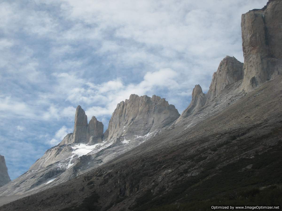
We left El Chalten on January 23rd and walked to Polacos, a campsite one hour beyond Niponino just below the approach to the rock towers south of Fitzroy. The approaches to Innominata, Saint Exupery, and De la S (the three towers south of Poincenot) all use the same rocky ramp system above Polacos. From the top of this ramp system we headed up the first gully between Innominata and Poincenot for a short distance before roping up.

West Ridge climbs the wall on the right then along skyline.
As we started our climb, the sun came up on the Torre group lighting up the granite with a bright orange.

Torre Group at dawn

Starting up our route

I led the first block that had several of the most difficult pitches on he route. It followed a crack system up a wall to the crest of the ridge that was mostly clean, enjoyable, Yosemite-like crack.

J following 2nd pitch

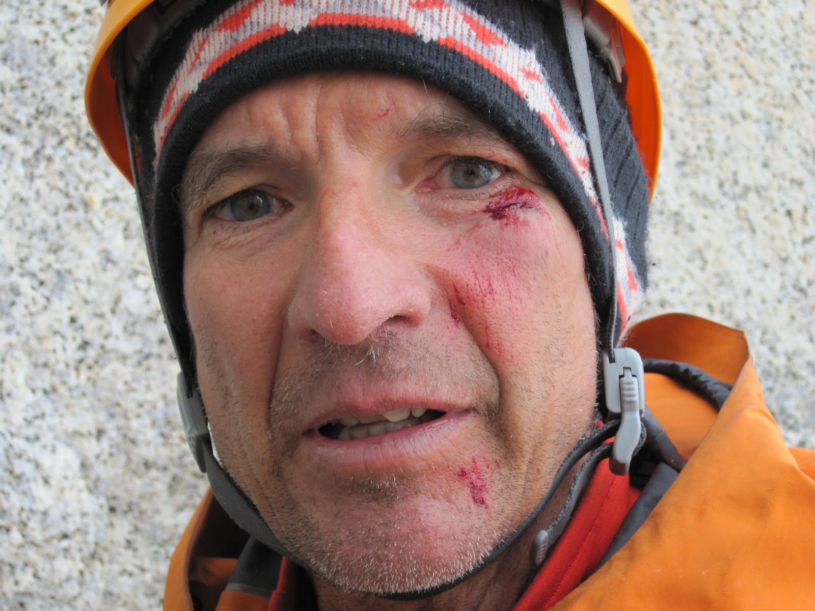
The third pitch climbed up a steep corner capped with a short five inch wide crack. I grovelled my way up this seemingly monolithic piece of rock, and as I grabbed a good hold at the top, a block of rock fractured off that I pushed aside as I came off with it. I suffered a minor scrape under my eye leaving me with a bit of a shiner. But fortunately it didn't seriously harm either of us. I had a good cam in the crack just below where the rock broke off that held my short fall.


I led the next cleaner, but more difficult, looking crack. According to the guide book we had twenty pitches on the ridge before the West Ridge intersected the Anglo-American route which had five more pitches to the top. To try and speed things up I grabbed gear to pull through a couple of difficult sections.

J following 4th pitch

J took over the lead after this with the idea that he would get us past the first tower on the ridge and then I would take over again and lead us around the second tower to the Anglo-American route.

J leading up the ridge

We had heard from some friends who had climbed this route, that after the initial steep pitches there was a lot of easy climbing that would go quickly.

Me climbing along the ridge crest

We did find some easier climbing, but the route finding to get around the first tower was complicated. We thought we could make up some time by climbing simultaneously while roped together. But we found the climbing and route finding just difficult enough that we belayed each pitch.

J leading crack to regain ridge crest

We ended up moving slower that we had hoped. This was our first long rock climb in the range and we could probably learn to move a lot faster with a bit more practice.

J did a great job getting us to the ridge crest between the first and second towers and it was my turn to lead again.

J between 1st and 2nd towers
To pass the second tower I climbed sideways in a series of squeeze chimneys.

Me in squeeze chimney

We got to the intersection with the Anglo-American route at 8PM, which was the route we would rappel down. We still had five more rope lengths to the summit of Innominata and if we kept going we would probably arrive after dark. Both of us didn't want to rappel an unknown route in the dark, so we headed down without climbing to the summit.

Descending
We finished the rappels into the gully between Poincenot and Innominata just as it got dark. We down climbed the gully to get to the ramp that would take us back to our camp. Unfortunately we did not register some key landmarks on the way up and we couldn't find the entrance to the ramp. We went up and down the gully several times without finding the way. So we finally decided to take a nap for a couple hours until it got light and we could see our way.

Waiting for dawn

After it got light we found the ramp and quickly descended to our camp at Polacos.

Camp at Polacos

We hiked back to Niponino and picked up everything we left there and made the long walk back to El Chalten.