Thursday, September 1, 2011

Establishing Advance Base Camp


The South Face of Sasser Kangri II sits above the South Shukpa Kunzang Glacier that eventually drains into the Shyok River.  During the summer months, the major rivers in the Karakoram, including the Shyok, become swollen with snowmelt - increasing flows to their yearly maximum.  To approach Sasser Kangri II  via the Shyok, we’d have to walk up the river gorge for days, trying to wade the swollen river channels each time they zigzagged between the cliffs on either side of a half-mile-wide floodplain.  We were told that this would be an impossible trek in the summer when the water would be too deep to wade.  In 2009 when we made our first attempt on SKII, we looked for a way to approach the mountain up a valley off the Nubra River and then cross over a high pass onto the South Shukpa Kunzang Glacier thaat would avoid having to come up the Shyok River.  In 2009 we explored side valleys above the Skang Lungpa Glacier where no one had ever been and discovered a 20,000 foot pass that took us over onto the South Shukpa Kunzang Glacier below Sasser Kangri II.  This year we followed that same route except that this time we brought skis to make the travel on the glaciers quicker and easier.


Col (pass) we crossed to get to Advance Base Camp

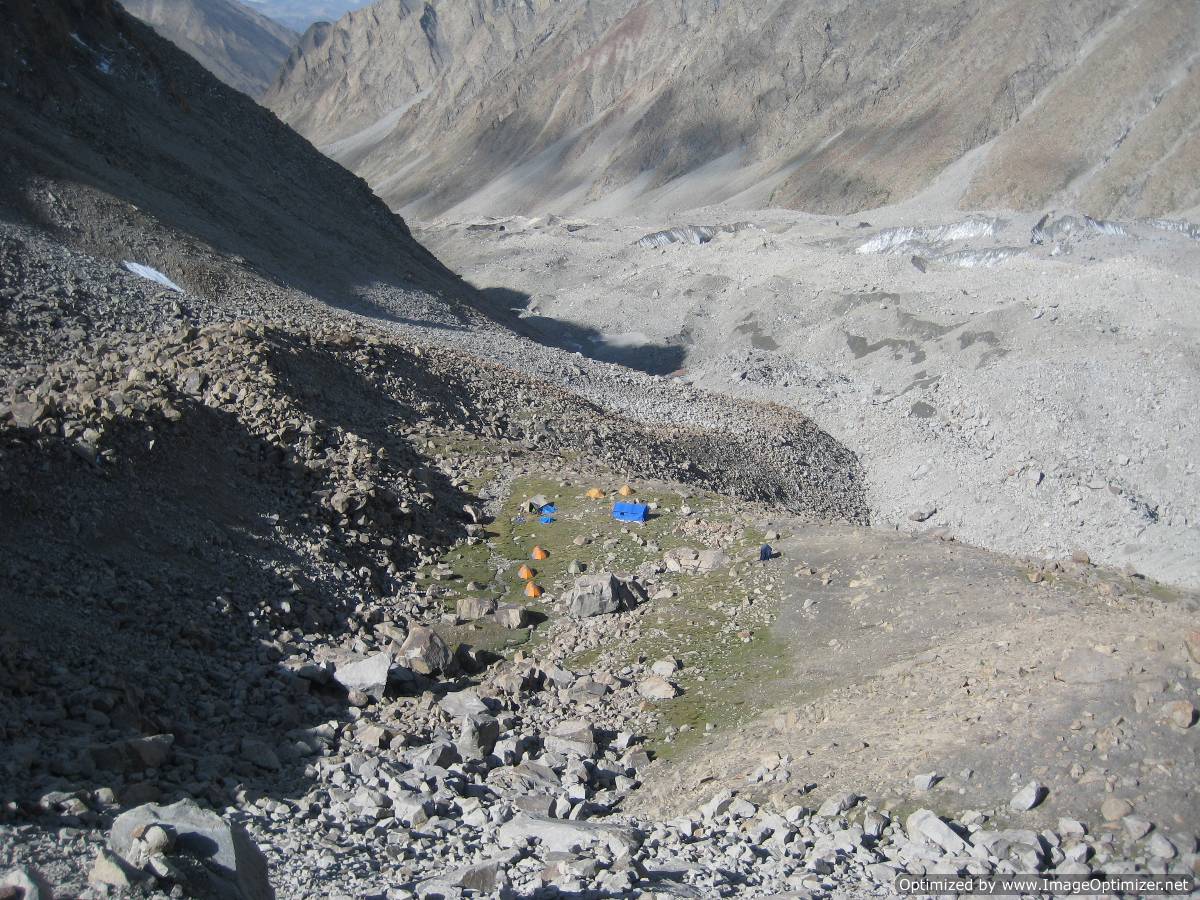
Once we crossed over the pass we placed a camp up the South Shukpa Kunzang Glacier below Sasser Kangri II that we called our Advance Base Camp (ABC).  We would operate out of ABC for our climb of SKII and any other acclimatization peaks we might attempt in the area.


Advance Base Camp

Sasser Kangri II from ABC - Route goes up rt side of giant couloir to half height - up ramp system on rt wall to summit .
One of our permit requirements for the Eastern Karakoram is we need to be a joint Indian=Foreign expedition.  To do a climb like Sasser Kangri II alpine style without fixed ropes and camps we cannot take Indian climbers with us who we don't know and do not have the prper experience.  We have challenged this rule with the permitting authority, the Indian Mountaineering Foundation along with a number of other issues that discourage climbers from coming to this region - so far to no avail.  So we engage a number of Indian citizens to be on our team as members who end up being there to help us carry loads places but don't actually climb on the mountain with us.  We try to give them opportunuituies to climb with us on smaller acclimatization peaks.  But they were an integral part of our team and included: Tinless, Dansing, Chirring, Pemba (aka King Kong), Tashi, and Palden.  Most of them were Sherpas from Darjeeeling, but also they are from Ladakh and Kaumon - all mountain areas in India where the locals are well suited to this environment.  These guys helped carry all the supplies and equipment from our base camp over the pass to ABC and when we were climbing over there they kept us supplied and watched over us in case we had an emergency or needed anything.

Pemba (aka King Kong for his legendary load carrying capacity)


Wednesday, August 31, 2011

Drive to Nubra Valley and Hike to Base Camp

As many of you may know, Mark Richey, Freddie Wilkinson and I successfully made the first ascent of Sasser Kangri II (7518 meters) in the Eastern Karakoram on August 24th.  I will resume the blog posts that I suspended while we were in the mountains with no internet connectivity.  So stay tuned as I post about our experiences with some photos over the next week or so.  I will start with our trek to base camp.

On Thursday July 7th we drove the six hours from Leh to the Nubra Valley and our road head. The road climbs up and over the Kardung La, an approximately  17,600 foot pass (the Indians claim it is higher than that) that they also claim is the highest motorable road in the world. The road over this high pass is the main access for India to the very northern tip of their country because they can't access it via the Shyok River, the main river basin north of the Kardung La, because it flows west into Pakistan - India's arch enemy.  The Line of Control that separates the two countries in disputed Kashmir is heavily militarized, so the Indians cannot access this area up the valley from Pakistan and going over this high pass is their only access. For several members of our group driving to the pass was their personal altitude record. 

 
Kardung La

Down the other side of the pass and up in the Nubra Valley we stayed at the Rimo Hotel and prepared all our loads for the porters to carry to base camp. On July 9th we left the main road at 10,000 feet and immediately climbed about 2000 feet up a steep arid hillside that placed us high on the south side of the river gorge that we would follow for the next three days to our base camp.


The distance is not all that great, maybe only 10-15 miles, but we would climb to 17,000 feet and we needed to take the time to acclimate to this elevation. At the top of the initial hill we traversed along a couple of miles of very treacherous hiking – steep rocky cliffs that didn't seem all that solid plunging several thousand feet into the river below.


Our camp that evening was on a flat dry plan past all the worst part of the trek and the next day we enjoyed a leisurely walk to a nice grassy meadow for our second camp. We would need to spend an extra night here so that our porter loads could catch up to us.


On July 12th we arrived at our base camp, the same one that Mark and I used in 2009 on our first attempt on Sasser Kangri II. It is a beautiful small meadow, unusual for this elevation where we will be spending a lot of time until we leave at the end of August.

Thursday, July 7, 2011

Arrived in Leh


The flight to Leh from Delhi was a bit protracted because when the plane arrived over the airport there it couldn't land due to weather or some problem with the airport. So we circled overhead for about 30-45 minutes waiting for conditions to improve. The nice thing about this was we kept getting a 360 degree panorama of the Karakoram all the way from K2 to Sasser Kangri II. It was exciting to keep seeing our soon to be climbing objective poking its head above the clouds. We were not able to land so we had to go back to Delhi where they refueled and we went back and landed this time without a hitch.

Karakoram from the air - K2 is in the upper left corner - Sasser Kangri II is just out of the picture on the right

In Leh we rested on July 6th and walked around town.  Leh is an interesting mix of Muslim but mostly Tibetal Buddhism culture.  In the photo you can see the town mosque with the monastery in the background.


On the 7th we visited some monasteries. I believe the two we visited were built in around the 16th century and have been well preserved. Much of their longevity is due to the very dry high desert climate that keeps things from rotting. I don't think these buildings would have lasted 100 years in my home climate in the Pacific Northwest.


At one of the monasteries some Indian workers were doing a photo shoot that seemed like an odd juxtaposition of cultures. But then given that Buddhism seems to be a religion that is open to all sorts of activities, everyone there was curious and no one seemed to mind.


Inside a couple of the monasteries there were beautiful golden statues of the Buddha.


Today we will drive over the Kardung La to the Nubra Valley where we will stay for two days. I've included a couple of pictures from 2009 along the drive.


We will likely stay at this guest house again in the Nubra valley that is run by a very nice Tibetan family.

On July 9th we will begin our three day trek to base camp. The first day climbs 3000 feet up a hillside to where we will traverse along a steep hillside above the gorge below. This first day is a difficult and treacherous walk and we need to take good care of ourselves and our porters who are very heavily laden. Again I've attached some photos from our 2009 attempt that shows some of the terrain along the steep traverse above the gorge on the first day.


I will not have internet access after today when I leave Leh, so my next blog posts on our expedition will be in late August or early September. Watch for some new posts then!

Monday, July 4, 2011

Back to Sasser Kangri II


Welcome back to my blog after a period of inactivity. I'm going to get back into it with some stories of my latest alpine adventure – our second attempt to climb Sasser Kangri II in the eastern part of the Karakoram Mountains of Kashmir

 
Southwest Face of Sasser Kangri II
Kashmir is a beautiful mountainous region where China, India,and Pakistan come together. Control of Kashmir is disputed between India and Pakistan, as well as between India and China . Several wars have been fought between India and Pakistan over Kashmir and once between India and China. China wrested control of an uninhabited part of Kashmir called the Aksai Chin claimed by India and the Shaksgam River valley north of K2 was given to them by Pakistani in a border treaty. So the Chinese seem happy now with their borders in the region. But the disagreement between India and Pakistan over most of Kashmir, like the Middle East, is one of the world's most intractable conflicts and drives much of the political instability across South Asia. The Indo-Pak Kashmir Conflict has resulted in a military and political stalemate so that Kashmir is now split between both sides along the Line of Control. The LOC is heavily militarized and the northern portion of it runs right through the Karakoram Mountains making it the highest battleground in the world.

Army trucks going over the Kardung La
About three quarters of the Karakoram Range, including K2, is on the Pakistan side of the LOC, but there are a number of spectacular peaks on the Indian side as well. Our objective – Sasser Kangri II -  lies on the Indian side of the LOC. This area, known as the Eastern Karakoram, has seen little climbing activity compared to the Pakistan side because the Indians only opened it recently and permits from India are difficult to obtain. But this also means the area has not been fully explored and many of the peaks are unclimbed.

Sasser Kangri II is nearly 25,000 feet high and the west summit was climbed by the Japanese in the early '80s, but the higher east summit has not seen an ascent making it one of the highest unclimbed mountains in the world. To get to SKII we will fly from Delhi to the town of Leh in the area of Kashmir called Ladakh.  From Leh we need to travel north to the Nubra Valley where we begin our trek to base camp.  But the only way we can go north from Leh is up and over the Kardung La pass.  This is because the Shyok and Indus Rivers that drain the eastern part of the Karakoram flow west over the LOC into Pakistan so that the approach to this most norther tip of India is not politically possible up these river valleys. To access this area the Indian's have constructed a road over the Kardung La, an 18,000 foot pass. The Indians can only keep this pass open in the summer so all the supplies to support their troops along the LOC in the Karakoram mountains must go over this pass during those months. After we drive over the Kardung La we will stay at a small hotel in the Nubra Valley before starting our trek to Base Camp.

Elevation of the pass is more like 17,600 ft - still pretty high
The Karakoram Mountains are one of the most spectacular and challenging places to climb and attracts mountaineers from all over the world. Due to security concerns along the LOC, the Karakoram has been open and closed to climbing over the years. But currently both India and Pakistan have been issuing climbing permits to promote economic development in the region and as a way to garner international recognition of the territory in Kashmir that they control

Indian soldiers headed for the LOC

The conflict continues to take its toll
In 2009 I attempted Sasser Kangri II with Americans Mark Richey and Mark Wilford, and a British climber Jim Louther. From the Nubra Valley we spent three days trekking to a beautiful small meadow that we discovered for our base camp at 17,000 feet. From here we had to find a way up one of several side valleys that would take us over a 20,000 ft pass and onto another glacier that drains the southwest side of SKII that we wanted to climb.

Base Camp
Fortunately the valley behind our base camp led to a snowy pass whose crossing involved glacier travel but no real technical climbing. We made numerous trips over this pass to acclimatize and to find a suitable climbing route up SKII.

Route climbs right side of big couloir - traverses right at half height and then up the wall
After spending over a month at or above base camp we made a serious attempt to climb the Southwest face of SKII and reached about 22,500 ft before retreating in bad weather. By then it was late in the season and our time had run out. I felt we had accomplished a lot with our reconnaissance of a completely unexplored area and getting fairly high on our route. I walked away convinced that we found a safe, but challenging, way to the summit. The route consisted of steep ice and surprisingly good granite and with the work we had put into it I wanted to return to finish the job.

Returning from the wall
At the base of the wall
1st Bivouac

Leading up the ice face at around 22,000 ft

Traversing right into the mixed climbing

2nd Bivouac

Descending to site for 3rd Bivouac
3rd Bivouac chopped out of hard ice
Retreat
It took a couple of years to arrange the team and get the necessary permits from the Indian Government. Yesterday I flew from Seattle to Newark and met up with my climbing partners Mark Richey and Freddie Wilkinson so that we could all fly to Delhi together and begin our second attempt on Sasser Kangri II. I will post several blogs about our expedition this year as far as Leh and maybe as far as the Nubra Valley. But after this my internet connectivity will be nonexistent and I will post what happened when I'm connected again in late August or early September.

Saturday, April 2, 2011

Late Season Rockies Ice

The ice climbing season in the Canadian Rockies is coming to a close and soon I will be returning to Seattle from Canmore.  The winter was not the best for ice - lots of very cold temperatures and lots of snow.  When the avalanche danger was high, the usual safe place to go near the Ghost River was very hard to get to because the unusual amount of snow drifted in and blocked the roads.  But in spite of all this we still had some great climbing in March as the pictures will attest!

John Roskelley leading the first pitch of Whiteman Falls
Twisted on the left and Glen Morangie on the right

Jiro leading mixed rock and ice on Glen Morangie


I'm leading the ice pitch on Glen Morangie

Near the top of Glen Morangie

Nemesis
Carter Stritch belaying halfway up Nemesis

Trophy wall - Terminator on the left (not fully formed) - Replicant in Center and Sea of Vapors on Right

John Freeman leading thin ice on the Replicant

Rob Smith leading the Whipper Traverse on Sea of Vapors

Looking down Sea of Vapors


Sunday, March 6, 2011

American Alpine Club - Presidents Message at Annual Benefit Dinner

Last Saturday the American Alpine Club held its Annual Benefit Dinner in Seattle.  As the current president I was honored to be the MC.  It was was a great event with awards to distinguished climbers, past and present like Fred Beckey, Bob Craig, Tom Frost, Hayden Kennedy, and Royal Robbins. 

I was proud to announce the adoption of a 5 year strategic plan by the AAC Board of Directors.  Implementing this plan will result in the most significant changes to AAC club programs in its 109 year history while at the same time preserving those aspects that honor our past.  The AAC needs to grow and change in response to an ever-changing world and to be a more inclusive community for all types of climbers.     

The AAC is changing what it does, but some things will never change - we will always hold fast to our values of Fortitude, Partnership, Creativity and Independence, and Stewardship. The AAC will continue to be that place of support and inspiration for the young and the old, for those who climb all the time and those who get out just as much as they can.  We will always be inspired by the achievements of Club members who explored the unexplored and pushed the boundaries of what was possible – those who built the tradition of excellence that inspires climbers today and is at the core of what the AAC is all about
Successful 1958 American Gasherbum I Expedition
The AAC's Vision is to "Advance the Climbing Way of Life”.  In the past, the AAC has delivered on this vision by honoring and recording our history and past achievements, performing advocacy and conservation work related to the places we climb, and providing in depth climbing information from around the world.  But in order to more fully deliver on our vision and meet the needs of the climbing community for the next 100 years, the AAC is building on our past accomplishments and: The AAC will resource the initiative to better engage local climbing communities by hiring a several Regional Coordinators across the United States.  These Regional Coordinators will help organize the climbing  community to ensure that important conservation and advocacy projects, social events, and community outreach work is accomplished.   
  • Engaging local climbing communities across the United States,
  • Making our hard copy information resources more available on-line,
  • Promoting climbing and conservation through an expanded grants program,
  • Improving member benefits like more insurance program choices and discounts, and
  • Expanding lodging options at national climbing destinations where they are inadequate 
We believe that our efforts will create more vibrant AAC communities where people live and climb and will result in increased membership to make the AAC more representative of the American climbing community. Our members, individual donors and industry partners have shaped this plan and will need to remain involved so we can sustain these important programs, projects and benefits.  
 
The recent effort to help save the Lower Index Town Wall,  is a good example of the kind of local projects where the AAC will be involved.  Index is a favorite destination of for the climbing community in the Northwest and is widely recognized as one of the best granite rock climbing crags in America.  In 2009 the AAC partnered with the Access Fund and the Washington Climber’s Coalition to raise money to purchase the Lower Town Wall at Index and build a toilet and other improvements.  The property was purchased and will be given to Washington State Parks – it is now known as the Stimson Bullitt Climbing Reserve and will be available to climbers in perpetuity.
 

Climbing has shaped who we are as people and the AAC provides opportunities for us to give back so that future generations of climbers will also benefit.  Climbing has reinforced in each of us the importance of taking responsibility for ourselves and being there for each other, of problem solving and mustering the grit to overcome great challenges, of taking a stand to protect what we hold dear, and of living life on our own terms.  These are the things that the AAC is about – the things that matter.

I encourage every climber to get involved in your community.  You can make a difference.

To read more about the AAC Annual Benefit Dinner go to the following link to Climbing magazine.