Monday, July 4, 2011

Back to Sasser Kangri II


Welcome back to my blog after a period of inactivity. I'm going to get back into it with some stories of my latest alpine adventure – our second attempt to climb Sasser Kangri II in the eastern part of the Karakoram Mountains of Kashmir

 
Southwest Face of Sasser Kangri II
Kashmir is a beautiful mountainous region where China, India,and Pakistan come together. Control of Kashmir is disputed between India and Pakistan, as well as between India and China . Several wars have been fought between India and Pakistan over Kashmir and once between India and China. China wrested control of an uninhabited part of Kashmir called the Aksai Chin claimed by India and the Shaksgam River valley north of K2 was given to them by Pakistani in a border treaty. So the Chinese seem happy now with their borders in the region. But the disagreement between India and Pakistan over most of Kashmir, like the Middle East, is one of the world's most intractable conflicts and drives much of the political instability across South Asia. The Indo-Pak Kashmir Conflict has resulted in a military and political stalemate so that Kashmir is now split between both sides along the Line of Control. The LOC is heavily militarized and the northern portion of it runs right through the Karakoram Mountains making it the highest battleground in the world.

Army trucks going over the Kardung La
About three quarters of the Karakoram Range, including K2, is on the Pakistan side of the LOC, but there are a number of spectacular peaks on the Indian side as well. Our objective – Sasser Kangri II -  lies on the Indian side of the LOC. This area, known as the Eastern Karakoram, has seen little climbing activity compared to the Pakistan side because the Indians only opened it recently and permits from India are difficult to obtain. But this also means the area has not been fully explored and many of the peaks are unclimbed.

Sasser Kangri II is nearly 25,000 feet high and the west summit was climbed by the Japanese in the early '80s, but the higher east summit has not seen an ascent making it one of the highest unclimbed mountains in the world. To get to SKII we will fly from Delhi to the town of Leh in the area of Kashmir called Ladakh.  From Leh we need to travel north to the Nubra Valley where we begin our trek to base camp.  But the only way we can go north from Leh is up and over the Kardung La pass.  This is because the Shyok and Indus Rivers that drain the eastern part of the Karakoram flow west over the LOC into Pakistan so that the approach to this most norther tip of India is not politically possible up these river valleys. To access this area the Indian's have constructed a road over the Kardung La, an 18,000 foot pass. The Indians can only keep this pass open in the summer so all the supplies to support their troops along the LOC in the Karakoram mountains must go over this pass during those months. After we drive over the Kardung La we will stay at a small hotel in the Nubra Valley before starting our trek to Base Camp.

Elevation of the pass is more like 17,600 ft - still pretty high
The Karakoram Mountains are one of the most spectacular and challenging places to climb and attracts mountaineers from all over the world. Due to security concerns along the LOC, the Karakoram has been open and closed to climbing over the years. But currently both India and Pakistan have been issuing climbing permits to promote economic development in the region and as a way to garner international recognition of the territory in Kashmir that they control

Indian soldiers headed for the LOC

The conflict continues to take its toll
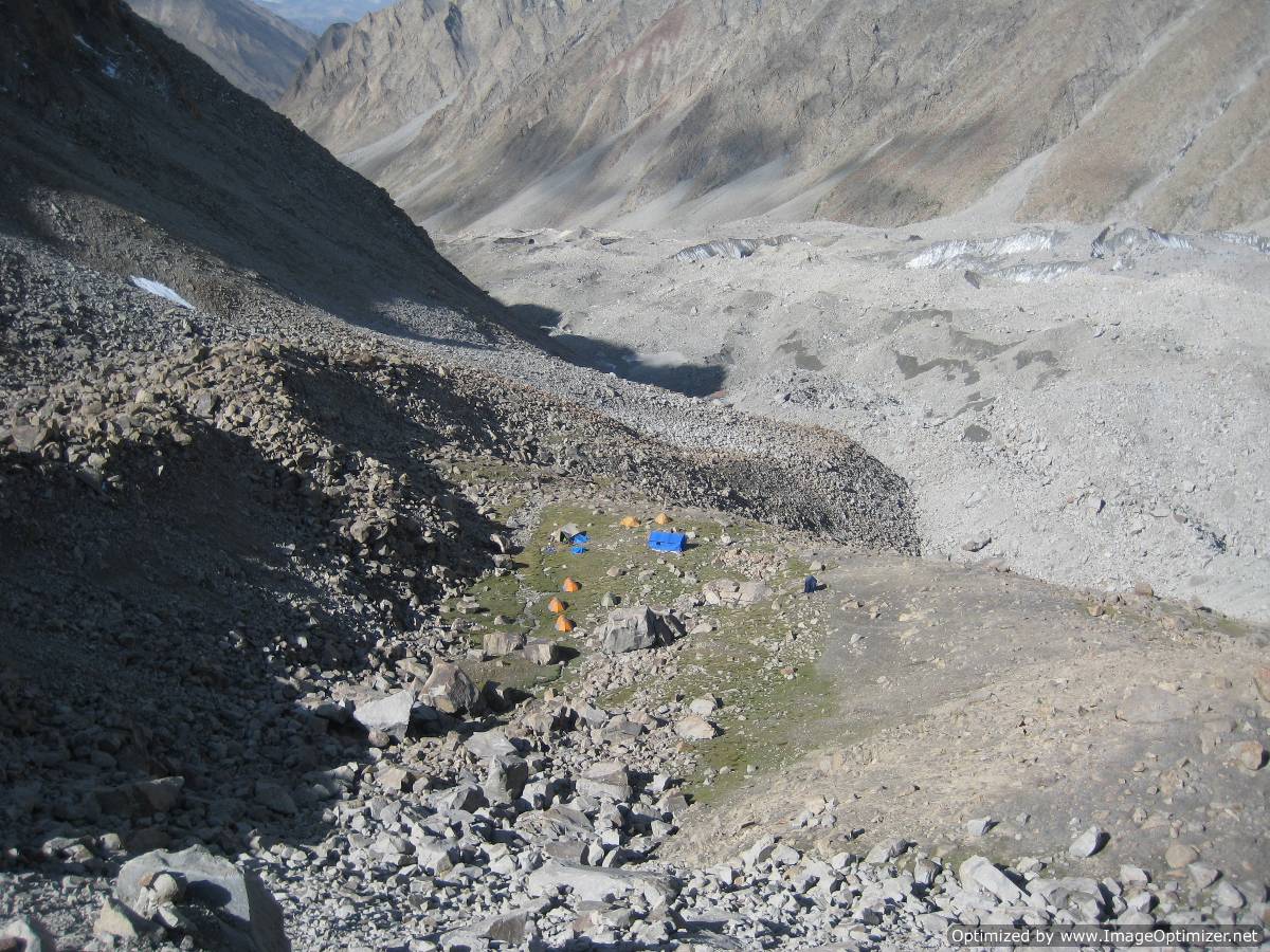
In 2009 I attempted Sasser Kangri II with Americans Mark Richey and Mark Wilford, and a British climber Jim Louther. From the Nubra Valley we spent three days trekking to a beautiful small meadow that we discovered for our base camp at 17,000 feet. From here we had to find a way up one of several side valleys that would take us over a 20,000 ft pass and onto another glacier that drains the southwest side of SKII that we wanted to climb.

Base Camp
Fortunately the valley behind our base camp led to a snowy pass whose crossing involved glacier travel but no real technical climbing. We made numerous trips over this pass to acclimatize and to find a suitable climbing route up SKII.

Route climbs right side of big couloir - traverses right at half height and then up the wall
After spending over a month at or above base camp we made a serious attempt to climb the Southwest face of SKII and reached about 22,500 ft before retreating in bad weather. By then it was late in the season and our time had run out. I felt we had accomplished a lot with our reconnaissance of a completely unexplored area and getting fairly high on our route. I walked away convinced that we found a safe, but challenging, way to the summit. The route consisted of steep ice and surprisingly good granite and with the work we had put into it I wanted to return to finish the job.

Returning from the wall
At the base of the wall
1st Bivouac

Leading up the ice face at around 22,000 ft

Traversing right into the mixed climbing

2nd Bivouac

Descending to site for 3rd Bivouac
3rd Bivouac chopped out of hard ice
Retreat
It took a couple of years to arrange the team and get the necessary permits from the Indian Government. Yesterday I flew from Seattle to Newark and met up with my climbing partners Mark Richey and Freddie Wilkinson so that we could all fly to Delhi together and begin our second attempt on Sasser Kangri II. I will post several blogs about our expedition this year as far as Leh and maybe as far as the Nubra Valley. But after this my internet connectivity will be nonexistent and I will post what happened when I'm connected again in late August or early September.

Saturday, April 2, 2011

Late Season Rockies Ice

The ice climbing season in the Canadian Rockies is coming to a close and soon I will be returning to Seattle from Canmore.  The winter was not the best for ice - lots of very cold temperatures and lots of snow.  When the avalanche danger was high, the usual safe place to go near the Ghost River was very hard to get to because the unusual amount of snow drifted in and blocked the roads.  But in spite of all this we still had some great climbing in March as the pictures will attest!

John Roskelley leading the first pitch of Whiteman Falls
Twisted on the left and Glen Morangie on the right

Jiro leading mixed rock and ice on Glen Morangie


I'm leading the ice pitch on Glen Morangie

Near the top of Glen Morangie

Nemesis
Carter Stritch belaying halfway up Nemesis

Trophy wall - Terminator on the left (not fully formed) - Replicant in Center and Sea of Vapors on Right

John Freeman leading thin ice on the Replicant

Rob Smith leading the Whipper Traverse on Sea of Vapors

Looking down Sea of Vapors


Sunday, March 6, 2011

American Alpine Club - Presidents Message at Annual Benefit Dinner

Last Saturday the American Alpine Club held its Annual Benefit Dinner in Seattle.  As the current president I was honored to be the MC.  It was was a great event with awards to distinguished climbers, past and present like Fred Beckey, Bob Craig, Tom Frost, Hayden Kennedy, and Royal Robbins. 

I was proud to announce the adoption of a 5 year strategic plan by the AAC Board of Directors.  Implementing this plan will result in the most significant changes to AAC club programs in its 109 year history while at the same time preserving those aspects that honor our past.  The AAC needs to grow and change in response to an ever-changing world and to be a more inclusive community for all types of climbers.     

The AAC is changing what it does, but some things will never change - we will always hold fast to our values of Fortitude, Partnership, Creativity and Independence, and Stewardship. The AAC will continue to be that place of support and inspiration for the young and the old, for those who climb all the time and those who get out just as much as they can.  We will always be inspired by the achievements of Club members who explored the unexplored and pushed the boundaries of what was possible – those who built the tradition of excellence that inspires climbers today and is at the core of what the AAC is all about
Successful 1958 American Gasherbum I Expedition
The AAC's Vision is to "Advance the Climbing Way of Life”.  In the past, the AAC has delivered on this vision by honoring and recording our history and past achievements, performing advocacy and conservation work related to the places we climb, and providing in depth climbing information from around the world.  But in order to more fully deliver on our vision and meet the needs of the climbing community for the next 100 years, the AAC is building on our past accomplishments and: The AAC will resource the initiative to better engage local climbing communities by hiring a several Regional Coordinators across the United States.  These Regional Coordinators will help organize the climbing  community to ensure that important conservation and advocacy projects, social events, and community outreach work is accomplished.   
  • Engaging local climbing communities across the United States,
  • Making our hard copy information resources more available on-line,
  • Promoting climbing and conservation through an expanded grants program,
  • Improving member benefits like more insurance program choices and discounts, and
  • Expanding lodging options at national climbing destinations where they are inadequate 
We believe that our efforts will create more vibrant AAC communities where people live and climb and will result in increased membership to make the AAC more representative of the American climbing community. Our members, individual donors and industry partners have shaped this plan and will need to remain involved so we can sustain these important programs, projects and benefits.  
 
The recent effort to help save the Lower Index Town Wall,  is a good example of the kind of local projects where the AAC will be involved.  Index is a favorite destination of for the climbing community in the Northwest and is widely recognized as one of the best granite rock climbing crags in America.  In 2009 the AAC partnered with the Access Fund and the Washington Climber’s Coalition to raise money to purchase the Lower Town Wall at Index and build a toilet and other improvements.  The property was purchased and will be given to Washington State Parks – it is now known as the Stimson Bullitt Climbing Reserve and will be available to climbers in perpetuity.
 

Climbing has shaped who we are as people and the AAC provides opportunities for us to give back so that future generations of climbers will also benefit.  Climbing has reinforced in each of us the importance of taking responsibility for ourselves and being there for each other, of problem solving and mustering the grit to overcome great challenges, of taking a stand to protect what we hold dear, and of living life on our own terms.  These are the things that the AAC is about – the things that matter.

I encourage every climber to get involved in your community.  You can make a difference.

To read more about the AAC Annual Benefit Dinner go to the following link to Climbing magazine.

Tuesday, February 8, 2011

Losar - One of the Worlds Longest Ice Climbs

Losar is the name for the Tibetan and Sherpa New Year, but it is also the name of a classic ice climb in the Khumbu region of Nepal near Mount Everest.  Although it is not exceptionally steep until the final two pitches, the climb is over 800 meters long which makes it one of the worlds longest ice climbs.  The route is approached by descending around 1000 feet from the village of Namche Bazaar and crossing the Bhote Koshi Nadi River to reach the climb on the opposite side.

Losar taken from the village of Namche Bazaar
Five days ago after we finished instructing at the Khumbu Climbing School Steve Mock and I decided to attempt the route before I headed back to the US.  I tried climbing the route the year before with Dave Weber, another KCS instructor.  But the morning of the climb Dave became sick from something he ate so we were not able to go.  While Dave recuperated, I went down to the river to check out the crossing and discovered that there wasn't a bridge, and without one the cascade was too swift and deep to cross safely.  So this year Steve and I went down the day before we started the climb to build a bridge using a 10 foot section of ladder.  But we discovered that locals had been mining sand from the river banks for concrete construction in Namche and they had built a sturdy log bridge that we could use the following day

Bridge built by sand haulers
We left on February 3rd (which was Losar) to climb Losar and arrived at the ice at first light.  It was unusually warm and the ice was running with water. 

Partway up Losar
Although the first 700 meters were relatively easy Grade 3 and 4, the wet, chandelier ice took time to clear. 

Namche Bazaar and the top of Mt Everest from Losar

We arrived at the steep final two pitches of ice as it was getting dark so we decided to turn around and rappel the route.  I was disappointed to miss out on this last section because it would have been the steepest and best climbing on the route.
We reached the top of the rock bulge on the right below the final steep section
Late that night we arrived back in Namche where our friend Nima prepared a simple meal for us before we went to our lodge for some sleep.  Maybe the third time will be a charm for me on this route!

Friday, February 4, 2011

Khumbu Climbing School

A couple of days ago I left the village of Phortse having completed my second year as a volunteer instructor for the Khumbu Climbing School.  The mission statement for the KCS is:

To increase the safety margin of Nepali climbers and high altitude workers
by encouraging responsible climbing practices in a supportive and community-based program


The KCS provides basic and advanced climbing instruction to the Sherpas and other ethnic groups in Nepal who are employed as guides for mountaineering expeditions in the Himalayas, including Mt Everest.  Many people assume that all the Sherpas are elite mountaineers and experts in their local terrain.  This is true for the experienced Sherpas, but for the aspirant Sherpa guides their occupation can be quite dangerous.  Most of their training comes on the job and Mt Everest is not the safest place to learn. 
The Village of Phortse
This year we had one student who had summited Mt Everest 8 times but did not know how to tie basic climbing knots. It is surprising that many of these Nepalis work on the highest mountains in the world with so little formal mountaineering instruction.  

Learning to ice climb
The goal of the KCS is to eventually train the Nepalis to be instructors so that they can run the school themselves.  2011 was the eighth year of the program and for each of the instruction groups, Nepalis now serve as the lead and assistant instructors with the American volunteers acting as safety observers. 


Rock climbing instruction
In addition to mountaineering instruction, the KCS provides some basic first aid training and English vocabulary.
First Aid Training
The KCS is run every winter when the guides are not busy working.  For the village of Phortse the KCS provides economic activity during a slow time of year when their are few trekkers and climbers around.

Even the local children want to learn their knots
At the end of the course there is a day of testing where students have to demonstrate in the field what they have learned.  The students are awarded points for skills like belaying, rappelling, ice climbing, climbing fixed ropes. knots, and first aid.  If they score a minimum amount of points they graduate and are given a certificate.   
Graduation


Thursday, January 27, 2011

Lukla to Phortse

Ann and I finally made the flight to Lukla from Kathmandu after going to the airport 8 days in a row.  The plane is a small twin turbo prop Donier that holds about 20 passengers.  The flight was spectacular with good views of the mountains including Mt Everest.  It is an exciting landing - you fly over a pass in the ridge that is visable in the background in the photo below just above the cloud layer.  The plane then drops down to the airstip on the side of the hill.  The reason the flight was cancelled for so many days was becase there were clouds in this pass.
Airport at Lukla
After we landed at Lukla which is at about 9,000 feet in elevation, we hiked for about 5 hours to the town of Monjo where we spent the night.  Monjo is at or below the elevation of Lukla because we dropped about 1000 feet from Lukla to the Dudh Kosi River before we started climbing again.  Along the way we came across many simple but beautiful Buddhist stupas (see post on Kathmandu) and piles of Mani stones.  Mani stones are rocks inscribes with Buddhist prayers.

Buddhist Stupa and Mani Stones along the trail
Along the trek between Lukla and Namche Bazar we crossed six cable footbridges.  Not that many years ago these bridges were made of vines and sticks and the new bridges make it possible to safely move people and cargo up the valley.  This plus the popularity of the trek to Mt Everest has made the Khumbu a relatively prosperous region in Nepal.

Ann on one of the cable footbridges over the Dudh Kosi River
On the second day of our trek we had to climb up about 2500 feet from Monjo to the village of Namche Bazar which is just under 12,000 feet.  We climbed above the tree line and began to get spectacular views of the mountains including the Kwangde peaks, Kusum Kanguru, Tamserku, Lhotse, Nuptse, and Mt Everest.  The view reminded me of the new route that Alex Lowe and I climbed on Kwangde Nup in 1989.  The upper part of the route is up the black rock wall visible on the peak furthest to the right in the photo below.
Namche Bazar and the Kwangde Peaks behind

We spent the night in Namche Bazar and on third day of our trek Ann and I headed to different places.  Ann went to the village of Kumjung with Liesl Clark and her children Finn (8), and Cleo (5) where they will be working at one of the Magic Yeti libraries.  Liesl and her husband Pete Athans have established several village libraries in this region of Nepal to help promote literacy.  I headed for the village of Phortse with Dave Weber, Kit Redhead, Pete Athans, Dave Burger, Dawa, and Chongba.  Phortse is the location of the Khumbu Climbing School and I will be able to get in a couple of days of teaching and a day of testing.  This is all that is left of this session of the KCS given that we are six days late getting here.  We had great weather on the hike to Phortse with views of the top of Mount Everest.

The top of Mt Everest behind the Lhotse-Nuptse wall on the left with Ama Dablam on the right

Saturday, January 22, 2011

Stuck in Kathmandu

We have been stuck for 5 days in Kathmandu waiting for weather that allows us to fly to Lukla.  To land at the airstrip in Lukla there needs to be clear weather, and for the past 5 days it has been too cloudy there for us to land.  Each morning we get a wake up call at 6, eat a hurried breakfast, go to the airport where we check our luggage, and then sit around in the departure lounge until around 1:00 PM when the airline cancels the flight.   After being on this same routine for the past 5 days, Ann and I feel a bit like the Bill Murray character in the movie "Ground Hog Day" where he keeps having to relive the same day over and over. 

To entertain ourselves we have gone shopping for gifts, and read a lot.  Today we went to a rock climbing gym where we taught basic climbing to several of the Sherpa students who are also stuck here in Kathmandu  trying to get to the climbing school.


Ann experiencing positive vibrations from the Buddha bowl

Sherpa students on Kathmandu climbing wall

Hopefully we will have better luck tomorrow and not just a repeat of the same fire drill!

Saturday, January 15, 2011

Kathmandu World Heritage Sites

Yesterday Ann and I visited several of the Kathamandu Valley UNESCO World Heritage Sites.  These are primarily ancient Buddhist or Hindu religious sites.  The first place we went was the Swayambhu Stupa.  A stupa is a mound-like structure containing  Buddhist relics, typically the remains of Buddha, that are used by Buddhists as a place of worship.  The Swayambhu Stupa dates back to the 5th Century where legend says a Buddhist follower planted a magic lotus that grew into a hill upon which the stupa was placed at the top. 

Swayambhu Stupa
Another popular name for the Swayambhu Stupa is the Monkey Temple. This is because monkeys are seen loitering all around the temple and are considered to be holy.  The holy man raising the hill was supposed to leave his hair short but he made it grow long and got head lice. It is said that the head lice transformed into these monkeys.

Monkey at Swayambhu
The next place we went to was the Patan Durbar Square which was the town square for the ancient city of Patan that has now been swallowed up by the larger municipality of Kathmandu.  Most of the temples in the Durbar Square are Hindu.
Patan Durbar Square
 The most entertaining part of our trip to Patan Durbar Square was being guided by Shalu, Naren, and his brother Ruben.  Shalu was 11 and Naren about 9 and Ruben maybe 7.  Shalu and Naren's English was very good and they were very sure about all the history of the site and the names of the various Hindu gods. We kept having to fend off a series of adults who tried to exert their authority over the kids by replacing them as our guides.  But we enjoyed giving them a chance to practice their English, and being kids they had a way of describing their world that was pretty funny.

Ann with out tour guides
 The last temple we visited was the Boudhanath Stupa.  At over 130 feet high and 120 feet in diameter - it's size, the ambiance of its surroundings, and the care with which it has been maintained, made it our favorite of the day.  We sat on a balcony having a beer watching the scene below as pilgrims made repeated journeys clockwise around the stupa turning the prayer wheels with their hands as they walked by and counting the number of mantras they had recited with the prayer beads they were carrying.  Several monks stood at the end of small wooden platforms that they used to prostrate themselves before the shrine, and they never stopped the whole time we were there - it looked like an endless set of situps.

Boudhanath Stupa
 The final stop of the day was a trip to the barber.  For about $10 he gave me a nice haircut and head and back massage.

Edward Scissorhands at work
Ann is spending time tomorrow sorting the books that have been donated and shipped to the Asia Foundation office in Kathmandu.  They will take these books to the Magic Yeti libraries located in several villages in the Khumbu region where she will be working while I'm teaching climbing at the Khumbu Climbing School in the village of Phortse.  We will fly to the small airstrip in the Town of Lukla on Tuesday so we can begin our trek to the villages where we will be doing our work.

Hong Kong 23 Years Later

On our way to Kathmandu, Ann and I had a 12 hour layover in Hong Kong.  Both of us had been here on the way to Beijing in 1988 when I negotiated the permit and costs for our subsequently successful expedition to the North Ridge of K2 in 1990.  In 1988 Hong Kong was still a British colony, but in 1997 it reverted to Chinese rule.  It was interesting to see how it had changed now that it was run by a communist government.  It appears to have become even more capitalistic now than before!  The underground subway stations were filled with upscale western retail stores, and religious banners were allowed.
 
Modern Subway Station


When the British left, the Chinese government implemented a principle of "one country, two systems" whereby Hong Kong has a different political system than mainland China.  It stipulates that Hong Kong have a high degree of autonomy in all matters except foreign relations and defense.

Religious Expression is Allowed
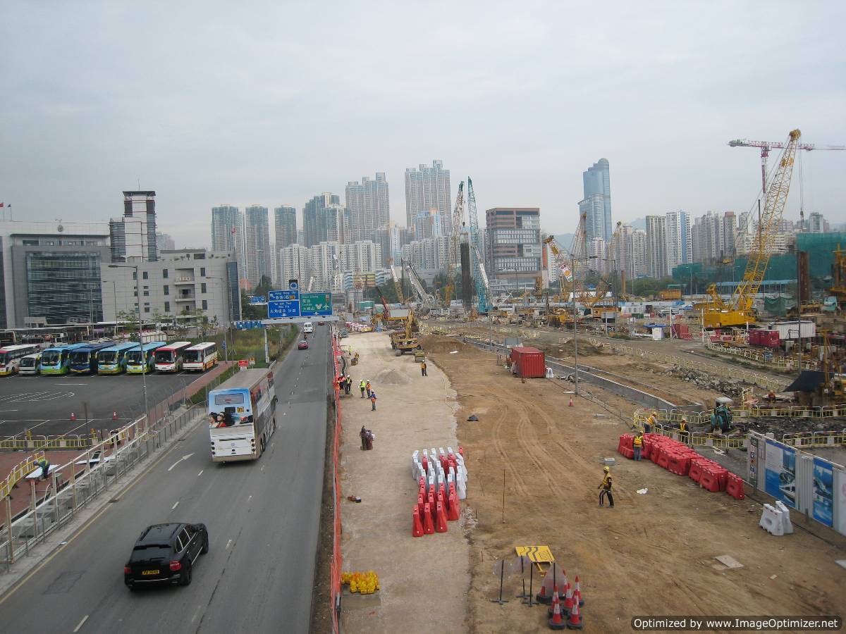
With this lack of interference, Hong Kong has remained as one of the worlds leading financial centers with its own currency the Hong Kong Dollar.  It is also one of the most densely populated areas in the world with the resources to construct an abundance of high rises to accommodate everyone, as well as extensive subway and highway transportation systems, modern port facilities, and a new airport.  There is obviously a lot of money here and it seems that practicality won out over ideology - the Chinese obviously did not want to bite the hand that feeds it.

Lots of construction in a Global Economic Downturn


Tuesday, January 4, 2011

Canadian Rockies Ice - So Far

Every ice climbing season in the Rockies is different.  When the temperatures drop below freezing each fall, the amount of water flowing over a waterfall or seeping through the rock can vary.  So ice climbs can be big and fat one year and nonexistent the next.  This year is no exception with the ice climbs on the Stanley Headwall thinner that usual and most of the classic routes in good condition.  A good place to get climbing information is at http://www.gravsports-ice.com/ or http://acmg.ca/mcr.  The photos below show conditions on some of the climbs I've been on this season.


Rob Smith and Jiro Kurihara on the first pitch of the Replicant
Juro Kurihara leading the second pitch of the Replicant
Jiro Kurihara approaching Kidd Falls
Jiro leading the first pitch of Kidd Falls
Sacre Bleu in lean conditions
Raphael Slawinski leading the thin ice on the first pitch of Sacre Bleu. Photo: Gery Unterasinger

Yours truly leading the fatter but steep second pitch of Sacre Bleu. Photo: Gery Unterasinger